Commercial - Residential - Agricultural - Industrial - Environmental - Geothermal - Construction
Whether you are thinking about drilling a water well on your property or about buying land and would like to know the potential for drilling on that property, you should consider many things.
There are no simple solutions, no detailed maps of ground-water presence, and no guarantees. But information is available that can be helpful when making a decision about whether to drill, or where to drill. This publication discusses points to consider when evaluating water-well potential and outlines basic steps to get the information you need. To further your understanding of the available information and why some areas provide water and others do not, we begin with a brief discussion of basic principles that govern ground-water occurrences.
Understanding Ground-water Systems
Ground Water on the Move: Ground water is defined as underground water found in the pore space of rocks. Ground water does not stay underground forever, and it does not lie still waiting for us to draw it from a well. Ground water moves as part of the hydrologic cycle, the endless circulation of water from the atmosphere onto the surface and into the subsurface regions of the earth and then back from the surface to the atmosphere (fig. 1). Precipitation becomes surface water, soil moisture, and ground water. Like surface water, ground water flows toward and into streams, rivers, marshes, and lakes. Ground water circulates back to the surface in this way, and, from the surface, water returns to the atmosphere through evaporation and transpiration (plant respiration).
The process by which water from rainfall and melting snow seeps into the soil and percolates into the saturated zone is called recharge. Places where recharge occurs are referred to as recharge areas. When this water reappears at the ground surface, this is called discharge. Besides flowing into streams, marshes, and lakes, ground water also may discharge in the form of springs and flowing wells.
Ground Water and Aquifers:
Many terms are used to describe the nature and extent of ground-water resources. The level below which all the pore spaces in the ground are filled with water is called the water table (fig. 1). The entire region below the water table is called the saturated zone, and water in this saturated zone is called ground water.
Figure 1–The hydrologic cycle. Precipitation falls to the earth’s surface, runs off or infiltrates the ground, then moves back to the surface and into the atmosphere through transpiration or evaporation. The alluvial aquifer is the cross sectional area shown in yellow and labeled alluvium.
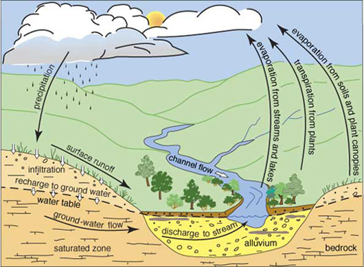
The hydrologic cycle
An Aquifer is an underground formation of permeable rock or loose material that can produce useful quantities of water when tapped by a well or as discharge via a spring.
Porous media aquifers consist of aggregates of individual particles such as sand or gravel. Ground water fills and moves through the openings between the grains. Porous media where the grains are not connected to each other are unconsolidated. For example, an alluvial aquifer consists of loose sand, gravel, silt, and clay deposited in a stream valley or floodplain, and it is hydrologically connected to the stream flowing on its surface (figs. 1 and 2). In consolidated aquifers, such as sandstone aquifers, grains in the porous media are cemented together.
Types of Aquifers
Unconfined Aquifers: These are typically easier and less expensive to drill into. Water in unconfined aquifers is more susceptible to contamination as there is no confining rock layer.
Confined Aquifers: These are surrounded by impermeable layers, making water more protected from surface contamination. However, drilling into confined aquifers can be more challenging and expensive due to the harder rock formations.
Figure 2–Confined and unconfined aquifers and how they affect water levels in wells screened in each type of aquifer.
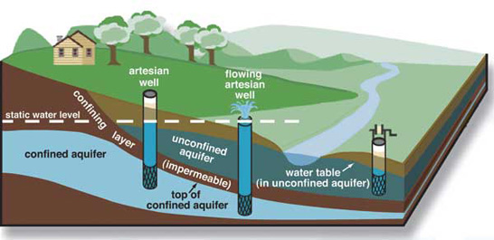
Confined and unconfined aquifers
Fractured aquifers are rocks in which ground water moves through cracks, joints, or fractures in otherwise solid rock. Some limestones are fractured aquifers.
Unconfined aquifers are bound by the water table; that is, they have no confining rock layers over the top of them (fig. 2). A well sunk into an unconfined aquifer will encounter water when the well reaches the water table, which is the approximate level at which water will stand in the well. Some aquifers, however, lie beneath layers of impermeable materials. These are called confined aquifers, or sometimes artesian aquifers. A well in such an aquifer is called an artesian well. The water in these wells rises above the top of the aquifer because of confining pressure; the level to which it rises is called the static water level. If the water level rises above the ground surface, a flowing artesian well occurs.
Drilling a well into an unconfined aquifer is often easier and less expensive than drilling into a confined aquifer. Unconfined aquifers are generally nearer the surface, so wells are shallower. Also, many unconfined aquifers are unconsolidated (for example, alluvial aquifers), thus more easily drilled, whereas confined aquifers more often are reached by drilling through hard rock. On the other hand, near-surface, unconfined aquifers are more susceptible to contamination than confined aquifers that are sealed off from surface contaminants.
Ground-water Quality and Contamination: Water is never found in a pure state in nature. Both ground water and surface water may contain many constituents, including minerals, microorganisms, gases, and inorganic and organic materials. Some are present naturally, and others are human-induced.
The chemical nature of water continually changes as it moves through the hydrologic cycle. Although ground-water chemistry depends, in part, on the initial chemistry of the precipitation and recharge water, the most important natural changes in ground-water chemistry occur in the soil. Ground water may dissolve substances it encounters or it may deposit some of its constituents along the way. The eventual quality of the ground water depends on the kinds of rock and soil formations through which it flows. Thus, ground water in some areas may be too salty or contain too much bicarbonate of soda for domestic use or irrigation. Iron content can be very high in some settings, which usually does not render the water unusable, but it can be a nuisance because of rust staining of plumbing fixtures and an undesirable taste and smell. It is advisable to have the water in a new well tested to determine its quality and suitability for use (see “Additional Information and Contacts”).
Evaluating the Potential for a Water Well
Here is a list of steps you can follow in evaluating the potential for a water well on a particular piece of property. Some steps are more critical than others, but each one can provide valuable information.
One of the first things you need to know is the specific location of the property. It must be stated in terms of the Public Land Survey System, that is, by the legal land description, or, in other words, by section, township, and range, and by quarters within the section. This step is necessary because all well records and land records are recorded in this way. Additionally, this information is important when locating the property on a county, topographic, or geologic map.
Your next step should be to determine what wells have been drilled in your area, to what depths, and with what results. This will usually indicate what you can expect to encounter on your property, although results can vary widely in some areas.
Geologic maps, topographic maps, and aquifer maps can provide information of varying utility. Geologic maps show the distribution of rock formations exposed at the surface, and thus indicate the nature and types of consolidated or unconsolidated materials in an area. The type of geologic materials and the topography of the earth’s surface in an area influence the location of ground water. Assessing these characteristics can help you determine the potential of a specific area to yield water to wells. For example, ground water generally exists nearer the surface and in larger quantities in valleys rather than in upland areas. In effect, the water table is not always a level surface, but rather a subdued version of the ground surface (fig. 1). A geologic map also can be useful in an area where ground water is virtually nonexistent in bedrock formations, but is plentiful in an adjacent alluvial aquifer along a major river.
Topographic maps, which show contours of surface elevations, provide information on the size, shape, and distribution of features on the land surface, as well as the location of lakes, swamps, springs, streams, and important cultural information such as buildings, railroads, and highways. They are useful for locating properties and for plotting wells by hand, if so desired. Topographic maps constructed on a 7.5-minute (1:24,000 scale) base are the most useful for siting well locations. They can be used in a manner similar to geologic maps to assess water-well possibilities, as in the example cited above, except that rather than having the alluvial aquifer shown in a different color than the surrounding area, one can only estimate its boundaries based on elevation contours. Vegetation also is shown and may indicate where near-surface ground water exists.
Talk to your neighbors. Many wells exist for which no paper records have been submitted, especially older wells, and the only information available may be from the owners. Even if a record does exist, the owner may be able to provide a history of the well’s production.
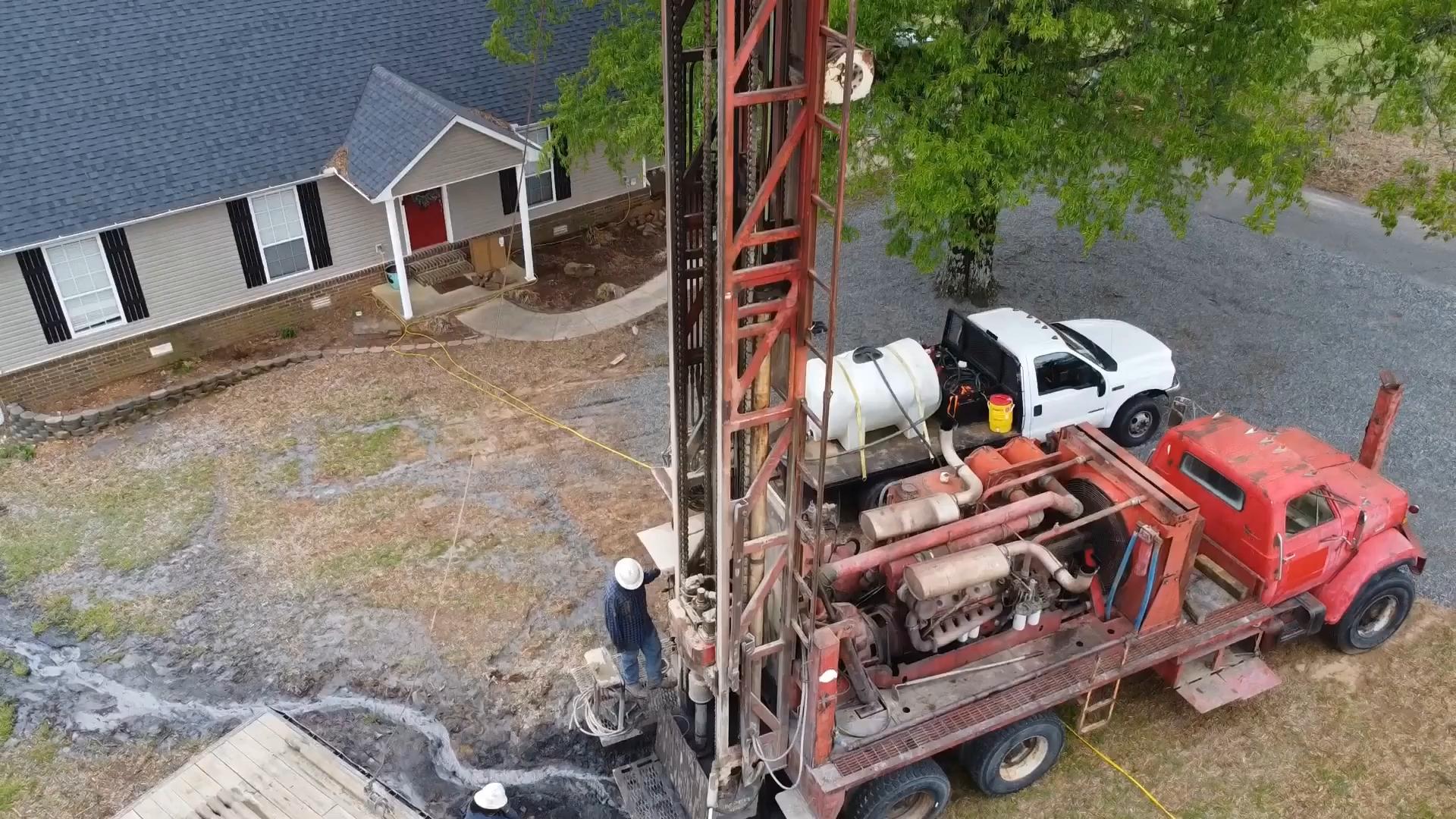
One of the most important steps in drilling a private water well is to select a reputable and responsible driller. Water-well contractors are available in most communities throughout the state. From their years of experience in the field, they possess a wealth of information about water-well possibilities in the areas where they have worked. Check local telephone directories for contact information.
Finally, be sure to check with local and State regulatory agencies for permitting and construction regulations. See contact information below.
Drilling a Well Versus Connecting to a Public Water Supply
Many landowners, in their quest for water, face a choice between drilling a water well on their property or connecting to the local municipal or rural water district. The advantages and disadvantages to each approach include the following:
Cost – Drilling a water well may involve a high initial cost, but the subsequent ongoing expenses, the cost of electricity for pumping the water and maintenance of the system, can be lower. Connecting to a water district also may involve a high initial cost, but it is often less than drilling a well. Subsequent monthly costs for water service can mount quickly if large amounts of water are used. Another important consideration is that a water meter generally improves the resale value of your property.
Risk – Drilling a well in many places can be risky. There are no guarantees that you will hit adequate water of good quality, even in areas where other wells have been successful. Connecting to a water district essentially removes the risk involved in obtaining a dependable, high-quality water supply.
Maintenance – When you have your own well, maintenance and its attendant costs are your responsibility. This can be troublesome, inconvenient, and expensive if pump, electrical, or piping problems arise. Being connected to a water district transfers most of the responsibility for maintenance to the district. Additionally, you most likely will still have water service even during electrical power outages at your house.
Availability – In some water districts, water meters are limited, and long waiting lists force applicants to wait years for a hookup. In such cases, a water well may be an attractive alternative if adequate ground water is available within reasonable drilling depths. In other places, no adequate ground water exists and connecting to a public water utility may be the only alternative, unless you are willing to have water hauled to your property and placed in a storage tank..tion installation, and enjoy the peace of mind that comes with knowing your water is safe and healthy.